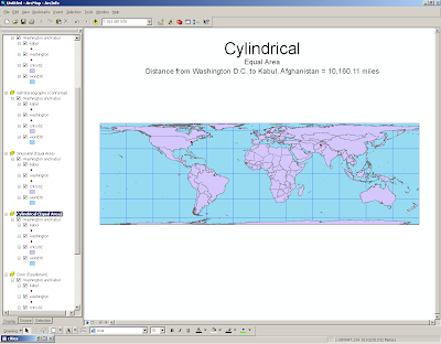


Every map projection is going to distort the earth in some way or another, but knowing which one to use in different situations is important. To determine this, it is important to look at the distortion of the 30˚ x 30˚ graticule, the distortion of the land masses, and the changing distances. It might be interesting to note that the actual distance between Kabul and Washington, DC is 6,930 miles.
The sinusoidal projection looks somewhat spherical, so the observer might think of a globe when looking at it. It is equal area, so the sizes of land masses are not distorted much except at the poles. It appears to be most accurate near the equator, but distances are greatly stretched. The Mercator projection also seems to be most accurate at the equator, but instead of being squeezed at the poles like the sinusoidal projection, it is vertically stretched, so Antarctica looks larger than all the other land masses put together, and Greenland looks larger than South America. It is obvious that the most northern and most southern 30˚ x 30˚ squares are greatly distorted because they are so much longer than all the others.
The Gall stereographic projection appears to display the land masses without much distortion, but it is important to note that vertical distances are somewhat exaggerated. This can be determined by looking at the shape of the graticules. This projection also has more distortion, but this is not as pronounced as it is in the Mercator projection.
It is interesting to compare the differences between the two types of cylindrical projection. The equidistant cylindrical projection stretches the image of the earth vertically, and the equal area cylindrical projection stretches it horizontally. The equidistant cylindrical projection provides, by far, the closest estimate of the distance between Washington, DC and Kabul. It would be interesting to see if the distance from one city to another city directly to the south would be as accurate, since this projection seems to distort north-south coordinates a lot. The equal area cylindrical projection flattens the image of the earth at the poles.
The conic projection presents a completely different shape of map. It seems to be an accurate view of the earth from above, with distances between longitude lines zero at the poles and increasing towards the equator, but there is one problem: Antarctica appears to be about 50,000 miles long. This is because the distance between longitude lines doesn't decrease towards the south pole. If an accurate view of Antarctica was needed, this projection could view the earth from above the south pole instead of the north pole.
No comments:
Post a Comment